| County: | Shawnee | |
| Address: | NW DOUGLAS RD | |
| Address Remarks: | 1/2 mile SW of Willard on Douglas Road | |
| City: | Willard | |
| Zip: | 66615 | |
| Parcel ID: | ||
| Legal Description: | NW 1/4 of Section 23 Township 11S Range 13E | |
| Legal Description Remarks: | ||
| Latitude, Longitude 1: | 39.08464 -95.93744 | |
| Latitude, Longitude 2: | ||
| Latitude, Longitude 3: | ||
| Latitude, Longitude 4: | ||
| Datum: | WGS84 |
| Historic Name: | Uniontown Cemetery | |
| Alternate Name: | Green Cemetery | |
| Historic Function: | Funerary | |
| Subcategory: | Cemetery | |
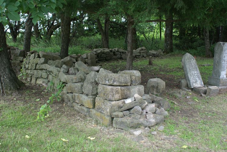
| Historic Function Remarks: | Three prominent areas of the cemetery are marked by stone walls. Two are of families ca. 1860s and the third, center is marked by a circular stone wall enclosing a mass grave of Potawatomi Indians, ca. 1849-1850. See site map. | |
| Present Function: | Funerary | |
| Subcategory: | Cemetery | |
| Present Function Remarks: | Last burials occurred in 1975 and 1997. The cemetery is now well-maintained but requires restoration of the stone walls. | |
| Residential/Commercial/Religious Style: | Not Applicable/No Style | |
| Secondary Style: | ||
| Barn Type: | ||
| Bridge Type: | ||
| Landscape Type: | ||
| Physical Description/Remarks: | Cemetery includes 1.21 acres, approximately 20 marked headstones, numerous unmarked burials. 3 separate marked burial areas, each enclosed with dry-laid stone walls. Scattered grave markers are also present outside these areas. | |
| Plan Form: | Not Applicable | |
| Commercial Building Type: | Not Applicable | |
| Roof Form: | Not Applicable | |
| Stories: | ||
| Condition: | Fair | |
| Principal Material: | Stone | |
| Condition Remarks: | ||
| Architect/Designer/Builder: | Not Applicable | |
| Year of Construction: | 1848 | |
| Certainty: | Estimated | |
| Date Notes: | Cemetery likely established c.1848. | |
| General Remarks: | Uniontown served as a trading post and pay station as early as March 1848. From the summer of 1849 and into 1850, a cholera epidemic took the lives of most of the people of Uniontown. Others fled. Many of the graves from those early years are marked only by crude limestone markers without names. A common mass grave in the center of the cemetery marks the burial of at least 22 Potawatomi Indians. Uniontown went on to exist as a town until 1854 when other towns along the Kaw River became crossing points for the wagon trains. The Uniontown Cemetery has other family burial plots, two marked by stone walls, ca. 1860s. The latest burials were in 1975 and 1997. | |
| Ancillary Structures: | Other | |
| Ancillary Structure Remarks: | Stone walls enclose three burial plots. See site map. | |
| Name: | Citizen Potawatomi Nation |
| Address: | 1601 S GORDON COOPER DR Shawnee OK 74801 |
| Address Remarks: |
| Listed in State Register: | No |
| Date of State Listing: | |
| Listed in National Register: | No |
| Date of National Listing: | |
| Historic District: | |
| Demolished: | |
| Date Demolished (if applicable): | |
| Potentially Eligible for National Register: | Yes |
| Register Status Remarks: | |
| Thematic Nomination (MPDF): | |
| National Historic Landmark: |
| Reviewed By: | |
| Review Status: | Approved |
| Click image or icon for a larger view or to open document. (opens new window) |

Uniontown Cemetery - Burial plot; W edge of cemetery view facing SE. RA 06/19/2009 |

Uniontown Cemetery - Burial plot W edge of cemetery view facing NE. RA 06/19/2009 |

Uniontown Cemetery - Burial plot W edge of cemetery view facing S. RA 06/19/2009 |

Uniontown Cemetery - Stone markers and headstond view facing S. RA 06/19/2009 |

Uniontown Cemetery - E view of common mass grave and Bourassa family plot. RA 06/19/2009 |

Uniontown Cemetery - View facing S of family plot. RA 06/19/2009 |

Uniontown Cemetery - Eliza Jane Mueller grave, ca. 1867 facing E. RA 06/19/2009 |

Uniontown Cemetery - W view of Bourassa family plot, ca. 1860s. RA 06/19/2009 |

Uniontown Cemetery - N view of Bourassa family plot, ca. 1860s. RA 06/19/2009 |

Uniontown Cemetery - E view of Bourassa family plot, ca 1860s. RA 06/19/2009 |

Uniontown Cemetery - E view of common mass grave ca. 1849-50. RA 06/19/2009 |

Uniontown Cemetery - W veiw of common mass grave ca. 1849-50. RA 06/19/2009 |

Uniontown Cemetery - N view of common mass grave ca. 1849-50. RA 06/19/2009 |

Uniontown Cemetery - E view of Bourassa family plot and common mass grave. RA 06/19/2009 |

Uniontown Cemetery - View facing N of early 1900s stone house built at site of pay station. RA 06/19/2009 |

Uniontown Cemetery site map |
|